MineSAT:
Satellite AI Openpit Mine Monitor
Governments and licensed mine operators require detection and scale of illegal mining and monitor mines for the purpose of volumetric analysis of mineral extraction as well as hazard detection.
Monitoring OpenPit Mines with Satellite Observation & AI
10+ Years of Satellite Imagery
Petabytes of Data Pre-processed
20+ GIS Parameters Analyzed
AI/ML Analytics & Predictions
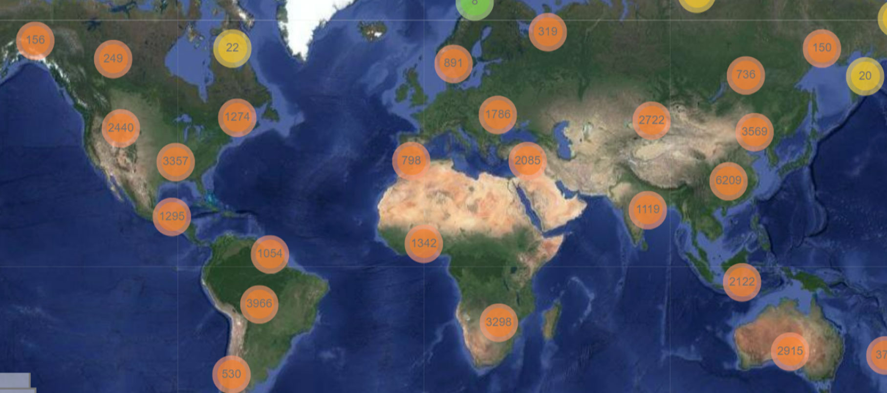
Researchers have mapped all Open Pit Mines in the world using satellites
MineSAT Applications
Detect and Monitor Illegal mining
Illegal mining has had devastating effects on forests and river channels, leading to negative downstream impacts on the health of local people, flora and fauna in several regions of the world. Illegal mining is often managed by organized crime who wield considerable power and influence in regions where they operate and are thus impossible to monitor and report. Satellite monitoring makes it possible to detect and monitor any and all indiscriminate and irresponsible illegal mining and thus protect the natural commonwealth, and prevent use of mercury and cyanide, which are poisonous and endanger the environment.
Abandoned Mine Monitoring
Our method is particularly advantageous in mining areas and tailing dams that have been abandoned, providing the only economical choice in ensuring safety regulations and site management practices.
ESG Impact Monitoring
For the mine operator abiding by local regulations and for project investors concerned with the Environmental, Social, and Governance (ESG) impacts of their funding dollars.
Building a Provenance Record
Our tools will enable compiling a provenance record of conditions — topographic, vegetative, hydrologic, and social (existing human development) with great accuracy.
This will form a baseline to track environmental and other disturbances caused by the mining activities moving forward.
continuous 3D volumetric mapping &
measurement of Open Pit Mines.
- MineSAT Artificial Intelligence (AI) monitoring of excavation operations, estimating volumes of extraction from mines
- AI Monitoring of land subsidence with down to millimetric accuracy
- Tailing dam integrity monitoring
- Surface water extent monitoring
- Detection of changes of the surface water within a mining area (e.g. tailing dams, surface run-off, and other water bodies)
- Frequent monitoring of land subsidence. Improve safety and efficiency of underground mining operations for raising warnings on possible infrastructure instability and collapses
- Detection of encroachment on the mining areas and illegal or dangerous settlements
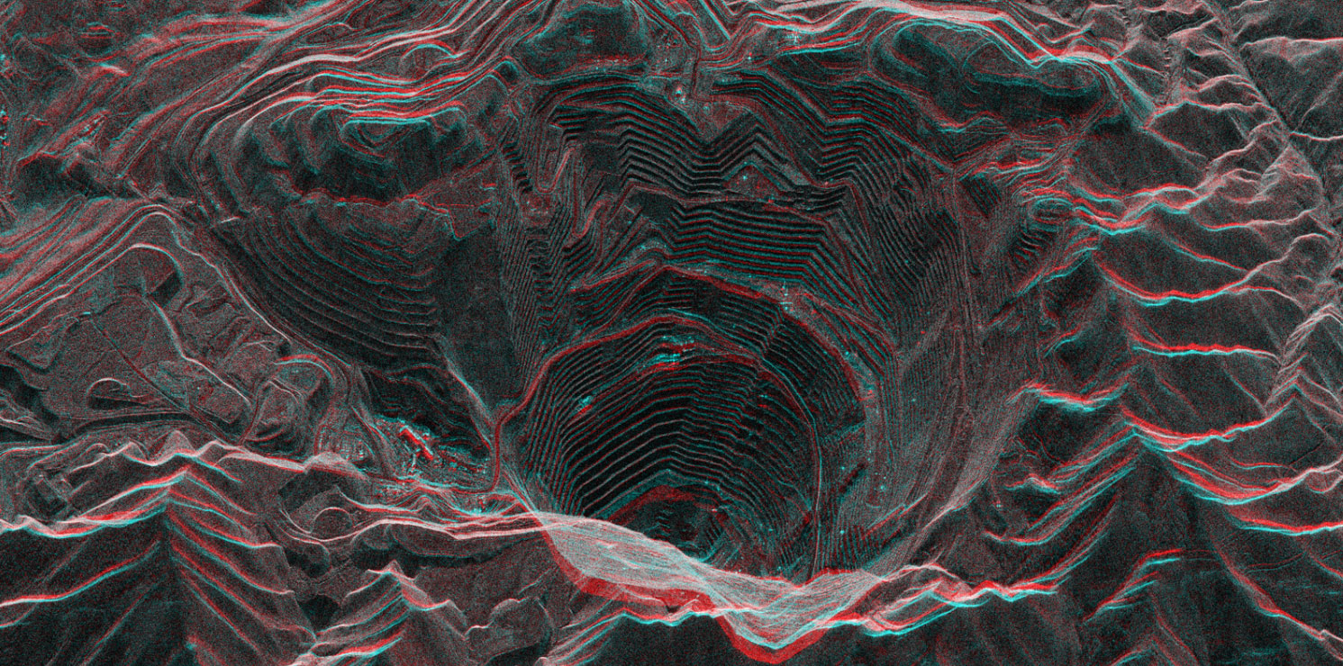
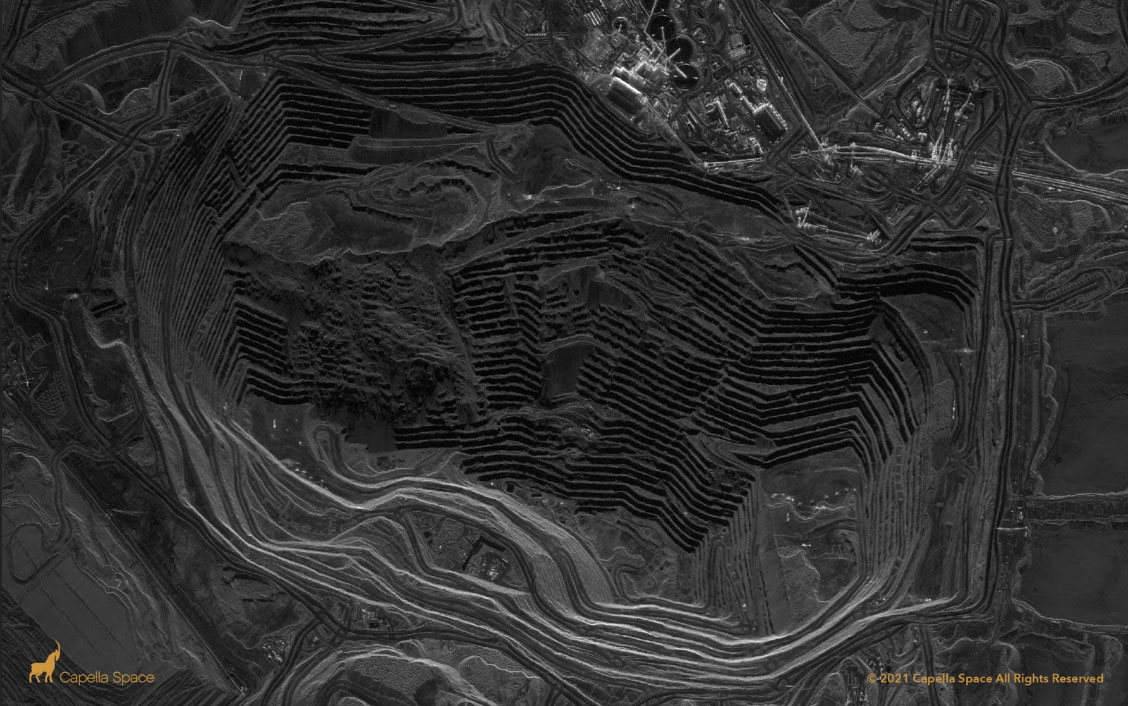
Open Pit Mine – Source ICEYE Satellite SAR Image
Geospatial data has traditionally been used on proprietary software by highly skilled personnel. Machine Learning and AL analysis of vast amounts of data with great speed on cloud lowers the cost, improves efficiency and accuracy and substantially increases capacity and Area Under Observation. The newest SAR satellites provide the precision thus far unavailable and ML / AL are the most optimal methodologies to process real time incoming data.
In recent years, efforts have been made to monitor and fight this activity by using optical satellite imagery. However, most of the areas being mined are prone to dense and near-constant cloud cover, preventing optical imagery from being used to keep local enforcement informed. The use of synthetic aperture radar (SAR) data has become increasingly popular in recent years because of its advantages over traditional sensors, particularly its ability to obtain information through clouds both day and at night.
ML /AL reduces cost and time of traditional Software skilled manpower intensive methodology.
MineSAT Innovation
We combine InSAR data with that from Sentinel 1 and Low Earth Orbit satellite constellations such as ICEYE and CAPELLA in near real-time much greater detail and precision. Machine Learning (ML) algorithms and AL improve with greater amounts of data processing and reduce costs over a period of time thus making the solutions widely application as they will be more affordable. We process petabytes of data on cloud platforms and use ML/AI thus increasing speed and reducing cost over time.Ongoing Monitoring
We are able to provide ongoing monitoring and real time analytics for governance and licensing / regulatory filings. ESG compliance requires the operator to monitor the condition of terrain and surrounding flora and fauna on a regular basis. If a toxic leak occurs, the site managers can react faster and act in time to remedy the problem before significant damage is done.About Us
We are an award winning team of space engineers, data scientists and AI developers. Our startup is winner of Dubai Air Show Space Challenge in December 2021.Efficiency
Accuracy
Asynchronous
Transparency
What we offer
MineSAT Open Pit Mine Monitor Dashboard and Decision Support System (DSS) represent game changing data driven solutions without the need for specialized GIS software or skills.
We have pre-mapped 5400 open pit mines around the world. Precision and regularity of local high precision monitoring is done as per requirements.
Email us: comms@forestsat.space
Image Credits: Satellite images credit to NASA, EOS, JAXA, Planet, Maxar, Airbus and corresponding space agencies / satellite companies.